A historical journey through the streets and houses of Trowse Newton.
The following format of this document basically follows Appendix 1 of the South Norfolk District Councils publication of 1997, entitled ‘Trowse with Newton Conservation Area Statement’ which was only ever issued in DRAFT form. There was an earlier one from 1985, but many alterations to the village makes much of it redundant, and the electronic version ‘Conservation Area Character Appraisal and Management Plan’ from 2012 does not differ much and although it includes many more colourful pictures, it appears too ‘functional’ and seems to have lost some of the author’s charm.
The layout of the village and this document is as follows; –
PART 1
Aerial photograph
Map of Conservation Area
Series of dated maps showing changes through the years
PART 2
Section 1 Kirby Road
Section 2 Devon Way
Section 3 The Street – East of Manor Rooms. a) North and b) South
Section 4 The Street – West of Manor Rooms. a) North and b) South
Section 5 White Horse Lane a) East and b) West
Section 6 Dell Loke & School Terrace
Section 7 Whitlingham Lane
The Conservation area, as designated in 1978, includes properties on both sides of the Street from St. Andrew’s Church and Whitlingham Lane to Crown Point public house; Blockhill Cottages and the frontage on the north side of Kirby Road as far as Stone Cottages; the Common and properties on both sides of White Horse Lane to a little beyond the converted farm buildings; Dell Loke, School Terrace and the Dell, together with land to the south (allotments) and to the east (Barn Meadow); meadows northwest of Whitlingham Lane, which fall within the Broads Authority and west of the Common, stretching to the stream which by-passes Trowse Mill; and meadows between this stream and the river Yare itself.
In 2010 the effectiveness of the boundaries was re-assessed to reflect the expansion of the village envelope since the construction of the bypass and the following changes have been made:
Updated to include the new development at Highland Crescent, Julian Drive, Devon Way, Charolais Close and Hudson Avenue, including the allotment gardens adjoining the rear of Devon Way, thus; extended boundary along the northern edge of the line of Kirby Road (now pedestrian only) to the bypass (A47), return south west along the bypass to the southern corner of the allotment gardens, then turn west to meet the existing boundary at the allotment gardens behind The Dell.
Also re-aligned at the northern boundary to include the whole of the White Horse public house car park.
Areas to the West (covering Millgate) are covered in a separate document which can easily be found online or with the hyperlink below
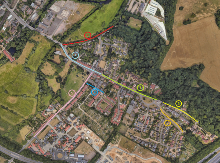
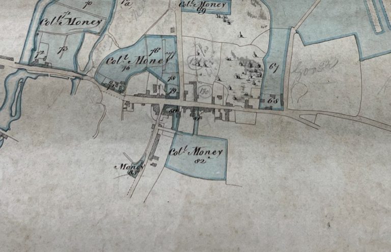
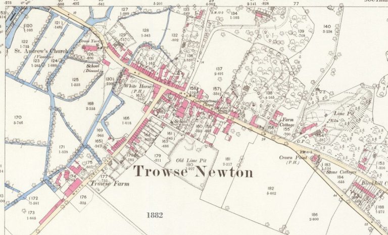
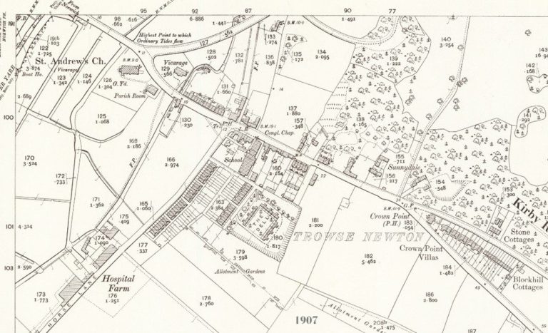
Working through the village in the same way as the 1985 format, there is nothing to see along the Kirby Bedon Road (Section 1) or Devon Way (formally Beccles Road – Section 2) except the Limekiln Cottage (or Point House) in plot 96.
Section 3 is the main street west of the Manor Rooms – Interesting to note that this is from the road running north, and at that time was the original Whitlingham Lane. On the North side, nothing survives today from Plot 130 which is now Meadow Close, but plot 129 includes Reading Room Cottages and Gothic Cottage. Plot 128 shows Aldburgh Cottages and Trowse Old Hall, while Plot 127, where Old Hall Farmhouse is now, (formally Sunnydale) shows several buildings that would appear to be very different to what is there now. On the south side, we must extend to take everything from the east of White Horse Lane, running south from the street from plots 197 to 207. There’s every indication that these houses to the south formed one of the ‘slums’ later cleared by Colmans. All of these to the west appear to have been rebuilt / restored later, with the only ones surviving in their original place being Easter and Newton Cottages, within plot 204.
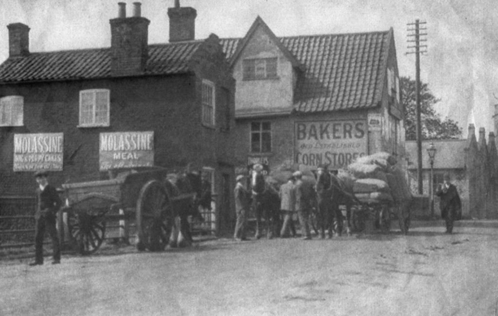
Section 4 is the main street east of the Manor Rooms – the only building to the south were the church in plot 166 and two other buildings in plot 168 which were the Baker & Sons Stores. The row of houses to the north are where Stanton Terrace is now, with White Horse PH (formally lime Kilns PH), Manor House & Manor Rooms to the east, running from plot 132 to 147. The houses further to the west opposite the church no longer exist.
Section 5 covers White Horse Lane, south of the Main Street. To the east is the Bakery (plot 197) and other unidentified buildings in 196 & 194, while a road, later covered under Section 6 and known as the Dell Loke can be identified, and then a set of terraces sit where Russell Terrace is now in Plot 190. To the west is the White Horse P.H. originally on the common before being ‘moved’. Further buildings line the west of the Lane, however, these too were removed. Further south the Old Hall Farmhouse and other farm buildings still exist in plot 173.
Lastly, Section 7 covers Whitlingham Lane, but as stated earlier. This was before it was moved with the entrance near the Church, so nothing recorded at this stage.
You can see that the two maps, both from 1844 are similar, although strangely, it does not indicate the Church.
There are no photographs from this time, however the painting on the left by Jennings shows Trowse Street with the Church in the centre. The area of Stanton Terrace and the old Limekiln P.H. to the right. After the first house on the left, which is River Greens position now, the gap is White Horse Lane. The first building after this was the original White Horse P.H. (later replacing the Lime Kilns opposite). The building between the White Horse and the Church is the Baker &. Sons Stores, shown in the later photograph on the right. (In the painting you can see a White Horse and also the window of the stores under a pitched dormer with blue tiled to the right).